
Attractions in Chittagong Hill Tracts
Misty hills and tribal heritage above the clouds ☁️⛰️
Showing 26 attractions · Sorted by importance

Buddha Dhatu Jadi (Golden Temple)
📍 Bandarban
🏘 Town / VillageA stunning golden Buddhist temple atop a hill, showcasing intricate Arakanese architecture and offering panoramic views of the surrounding wilderness.

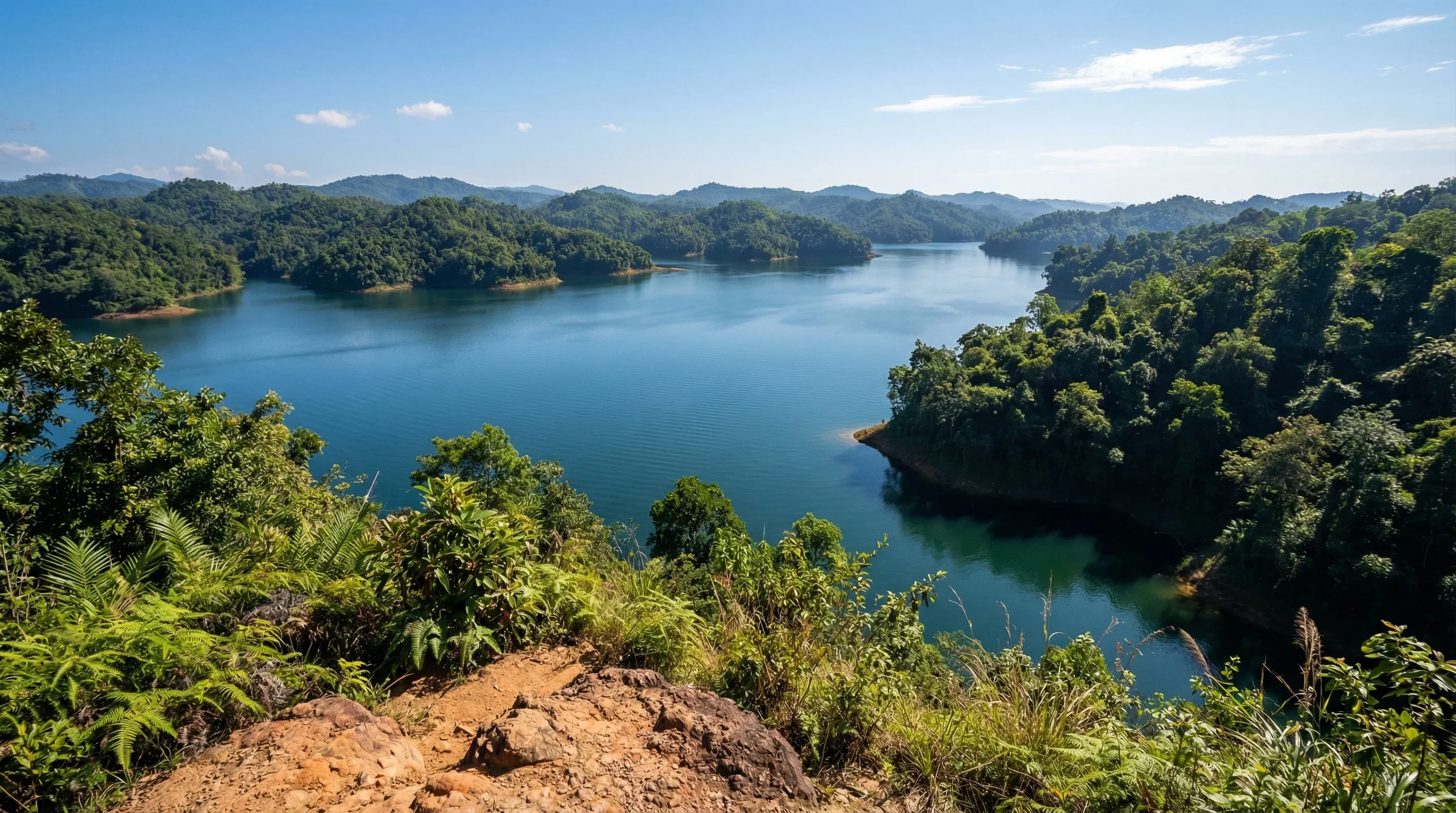
Kaptai Lake
📍 Rangamati
🏔 Scenic ViewBangladesh's largest man-made lake, perfect for family boat trips amidst serene hills and small island villages.

Kaptai National Park
📍 Rangamati
🌲 NatureA lush tropical rainforest conservation area on the banks of Kaptai Lake, offering scenic forest trails and opportunities for birdwatching.

Keokradong Peak Trek
📍 Ruma
🥾 Hiking & CyclingA 14km moderate-to-challenging trek starting from Boga Lake to the peak of Keokradong. Typical duration is 2 days including the ascent and return. Elevation gain is approximately 600m from the starting lake. Mandatory local guides are required. Equipment can be sourced via Dhaka-based trekking clubs like 'Bangla Mountaineering and Trekking Club'.


Sajek Valley
📍 Baghaichari
🏔 Scenic ViewKnown as the 'Queen of Hills', this high-altitude destination offers breathtaking views of rolling clouds and lush green mountains.

Thanchi-Alikadam Road (Dim Pahar)
📍 Thanchi
🚗 Road Trip33km paved mountain pass (1.5-2 hours). Known as the highest motorable road in Bangladesh, reaching an altitude of 2,500ft at Dim Pahar (Egg Hill). Key highlights include the hairpin turns, steep gradients through the Arakan Mountains, and panoramic vistas of the Sangu River valley.

Bandarban-Nilgiri Scenic Drive
📍 Bandarban
🚗 Road Trip48km paved ridge road (2 hours). This route traverses the Chimbuk Hill range, one of the highest in the country. Highlights include the Chimbuk Hill viewpoint, Shoilo Propat waterfall, and the Nilgiri resort area, famous for its views of clouds floating below the peaks and Mru tribal villages.

Meghla Tourist Complex
📍 Bandarban
🐄 FarmA major family destination featuring a mini-zoo with deer and birds, hanging bridges over a lake, and boat rides in the lush hills.

Nilgiri Mountains
📍 Bandarban
🏔 Scenic ViewOne of the highest peaks in Bangladesh, managed by the military, offering a safe and stunning viewpoint above the clouds.

Rangamati Parjatan Complex
📍 Rangamati
🧗 AdventureThe central tourism hub of the district featuring the famous 335-foot hanging bridge and serving as the primary base for boat tours of Kaptai Lake.
Sajek Valley Road
📍 Khagrachhari
🚗 Road Trip70km paved hilly road (3 hours). A popular touring route that winds through the remote hills of Khagrachhari and Rangamati districts. Highlights include the Bagaihat forest area, the Kasalong River crossing, and the dramatic ascent to the Sajek Valley ridge which sits at 1,800ft on the Indian border.

Sangu Matamuhuri Wildlife Sanctuary
📍 Bandarban
🌲 NatureA remote and pristine protected area known for the winding Sangu River, dramatic limestone cliffs, and untouched mountain rainforests.

Alutila Eco Park
📍 Khagrachhari
🌲 NatureA natural hill park famous for its 100-meter long mysterious dark stone cave and stunning viewpoints overlooking the Khagrachhari valley.

Amiakhum and Satvaikhum Trail
📍 Thanchi
🥾 Hiking & CyclingA challenging 25km multi-day trek leading to the Amiakhum waterfall. Includes river crossings, steep bamboo-laden slopes, and traditional bamboo rafting through deep canyons. Typical duration is 3 days. Elevation gain is moderate but terrain is slippery and technical. Managed by local tribal guides.

Aranyak Water Park
📍 Rangamati
🌊 Water ParkAn army-managed aquatic center featuring the Happy Island water park with multi-colored slides and swimming pools overlooking Kaptai Lake.

Jhulanta Bridge
📍 Rangamati
🏛 LandmarkAn iconic 335-foot long suspension bridge over the turquoise waters of Kaptai Lake, serving as the primary symbol of Rangamati tourism.
Nilachal
📍 Bandarban
🏛 LandmarkAn iconic viewpoint on a 2,000-foot high hill offering a sweeping 360-degree view of the Bandarban landscape and evening sunsets.
Rangamati-Kaptai Lakeside Road
📍 Rangamati
🚗 Road Trip35km paved lakeside drive (1 hour). This scenic route follows the winding eastern bank of Kaptai Lake, the largest man-made lake in Bangladesh. Highlights include continuous views of the turquoise water, emerald green hills, forest plantations, and proximity to the Kaptai Dam and National Park.
Saka Haphong (Mowdok Mual) Trek
📍 Thanchi
🥾 Hiking & CyclingAn expert-level 45km multi-day wilderness trek to the highest point in Bangladesh. Typical duration is 4-5 days through remote jungle and riverbeds. Total elevation gain exceeds 1,000m. This route is extremely remote with no cell service. Local guides from Thanchi are mandatory for security and navigation.

Tribal Cultural Institute Museum
📍 Rangamati
🏘 Town / VillageA museum dedicated to preserving and showcasing the unique cultural heritage, traditional dress, and historical artifacts of the region's indigenous groups.

Alutila Mysterious Cave
📍 Khagrachhari
🏛 LandmarkA natural 100-meter long dark stone cave that visitors can explore using traditional bamboo torches, located within a lush park.

Tajingdong (Bijoy) Peak Trail
📍 Ruma
🥾 Hiking & CyclingA challenging 22km trek often combined with the Keokradong route. Typical duration is 3-4 days from Ruma Bazar. The trail features significant elevation changes through tribal villages and dense vegetation. Elevation gain is roughly 800m. Requires official permits and local guide accompaniment from the Ruma Army Camp.
Bandarban to Thanchi Road Cycling Route
📍 Bandarban
🥾 Hiking & CyclingA challenging 80km road cycling route featuring the famous 'Dim Pahar' (Egg Hill), the highest motorable pass in the country. The route involves steep gradients and over 1,500m of cumulative elevation gain. Typical duration is 1-2 days. Bike rentals are primarily available in Dhaka from shops like CycleLife Exclusive (cyclelifebd.com).