
Attractions in Chin & Kachin States (remote)
Wild frontiers and misty mountain peaks 🏔️🌲
Showing 20 attractions · Sorted by importance

Indawgyi Lake Wildlife Sanctuary
📍 Mohnyin
🏔 Scenic ViewOne of the largest inland lakes in Southeast Asia, this UNESCO Biosphere Reserve features the iconic floating Shwe Myitzu Pagoda and diverse migratory birdlife.

Kachin State Cultural Museum
📍 Myitkyina
🔬 ScienceCultural museum displaying traditional Kachin ethnic artifacts including national costumes, traditional looms and textile patterns, silverware and jewelry, household utensils, musical instruments, weapons, and models of traditional Kachin houses.

Myit-son (Ayeyarwady Confluence)
📍 Myitkyina
🏘 Town / VillageThe sacred birthplace of the Ayeyarwady River where the Mali and N'Mai rivers converge, holding deep cultural and symbolic meaning for the Kachin people.

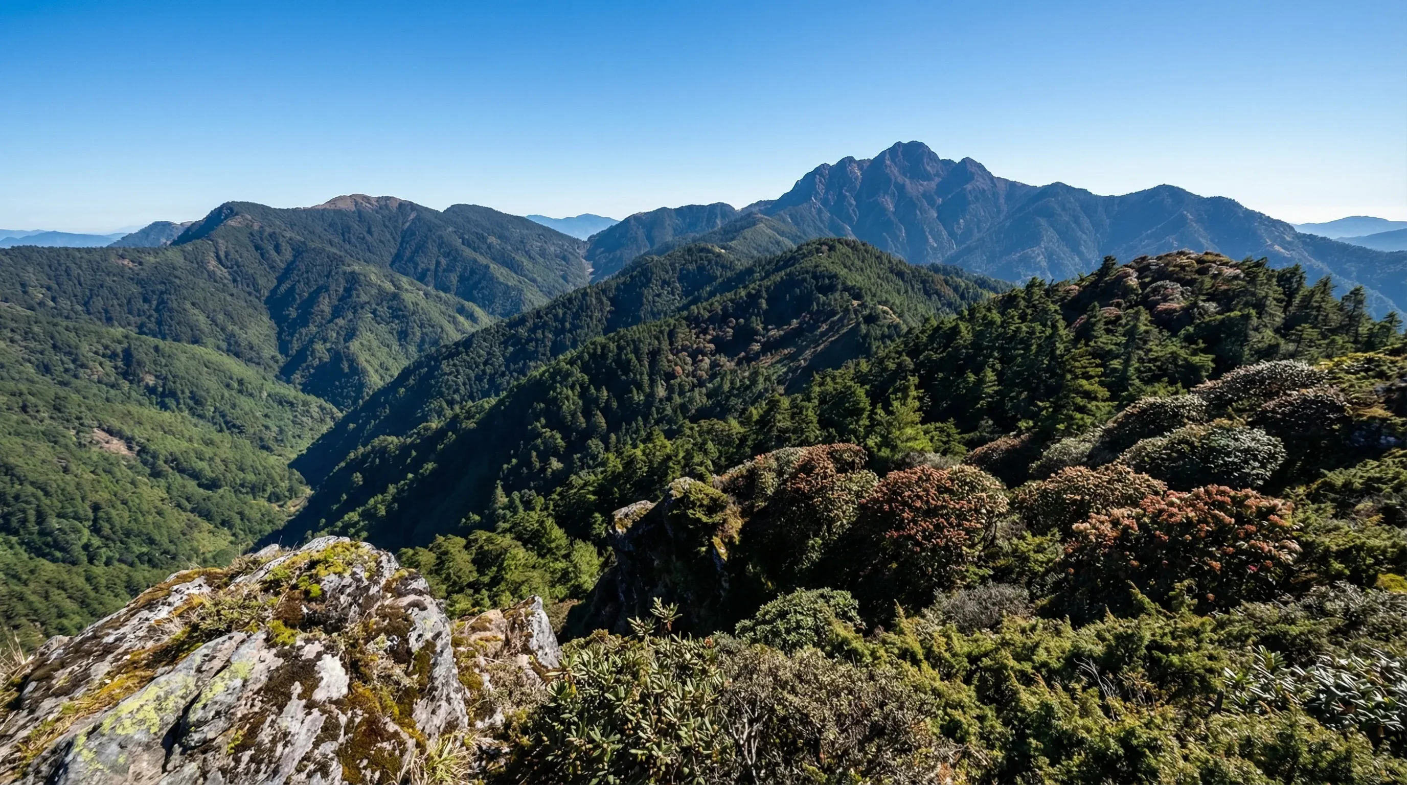
Nat Ma Taung (Mount Victoria) Summit Trail
📍 Kanpetlet
🥾 Hiking & CyclingModerate summit hike from the trailhead to the twin peaks, typically taking 2-3 hours round trip. The last 3km are usually done on foot, passing through rhododendron forests (blooming Oct-Feb) and offering 360-degree panoramic views of the Chin Hills. The trailhead is located 45 minutes drive uphill from Kanpetlet. Guide services available.
Nat Ma Taung National Park
📍 Kanpetlet
🏔 Scenic ViewThe highest peak in Chin State offers breathtaking panoramic mountain views and is home to rare alpine flora and unique bird species.

Mindat-Kanpetlet Scenic Road
📍 Mindat
🚗 Road Trip65km narrow paved mountain road (3-4 hours) traversing the ridges of the Chin Hills. This route connects the two main gateways to Nat Ma Taung (Mount Victoria) National Park, offering panoramic views of the surrounding valleys, traditional Chin tribal villages, and dense forests filled with rhododendrons and pine trees.

Shwe Myit Zu Pagoda
📍 Indawgyi Lake
🏘 Town / VillageA stunning gold-gilded floating pagoda on Indawgyi Lake, serving as the spiritual heart for the Shan-ni people and a major pilgrimage site.

Indawgyi Lake Cycling Loop
📍 Lonton
🥾 Hiking & Cycling90km moderate-to-challenging cycling route encircling Myanmar's largest lake. Mostly flat but with unpaved, muddy sections; takes 1-2 days depending on fitness. Elevation gain is minimal. Bicycle rentals are available at the Indawgyi Wetland Education Centre in Lonton village.

Indawgyi Lake Wildlife Education Centre
📍 Lonton
🔬 ScienceA discovery center providing interactive exhibits on the unique biodiversity and endemic species of the Indawgyi Lake UNESCO Biosphere Reserve.

Kachin Manau Park
📍 Myitkyina
🏛 LandmarkThe central cultural and historic site of the Kachin people, featuring tall, brightly decorated Manaw poles used for traditional ancestral festivals.
Kalay-Hakha Mountain Highway
📍 Kalay
🚗 Road Trip130km winding mountain highway (6-8 hours) ascending from the plains of Sagaing into the high peaks of the Chin Hills. The road is fully paved and features dramatic switchbacks with a vertical gain of over 1,500 meters. Highlights include the 'S' curves near Falam and expansive views of the Manipur River valley.
Kanpetlet Cultural Area
📍 Kanpetlet
🏘 Town / VillageThe gateway to Nat Ma Taung National Park, known for its preservation of traditional Chin village life and its scenic, cool-climate mountain setting.
Mindat Cultural Area
📍 Mindat
🏘 Town / VillageA high-altitude cultural hub offering insight into the traditional customs, unique facial tattoos, and mountain heritage of the Southern Chin ethnic groups.
Mindat to Kanpetlet Cultural Trek
📍 Mindat
🥾 Hiking & Cycling55km challenging multi-day trek (typically 3-4 days) through the Chin mountain range. Total elevation gain exceeds 2,500m. The route connects remote ethnic Chin villages. Equipment and local guides are required and can be arranged in Mindat via local guest houses.
Myitkyina to Indawgyi Lake Route
📍 Myitkyina
🚗 Road Trip175km paved but bumpy road (5-6 hours) through the heart of Kachin State. The journey passes through tropical teak forests and rural agricultural landscapes before arriving at Indawgyi Lake, Myanmar's largest inland lake and a UNESCO Biosphere Reserve. Key highlights include the crossing of the Irrawaddy River and the scenic approach to Shwe Myitzu Pagoda.

Rih Lake
📍 Rihkhawdar
🏔 Scenic ViewA striking heart-shaped natural lake located on the India-Myanmar border, surrounded by legend and scenic forested hills.

Rih Dil
📍 Rihkhawdar
🏔 Scenic ViewA serene, heart-shaped natural lake located near the Indian border that provides a picturesque setting for family walks and photography.
Bungtla Waterfall
📍 Matupi
🏔 Scenic ViewA spectacular multi-tiered waterfall nestled deep in the Chin hills, known for its pristine natural beauty and cooling mountain spray.
Hsu Taung Pye Pagoda
📍 Myitkyina
🏛 LandmarkA prominent and beautifully maintained riverside pagoda that serves as a center for religious life and offers panoramic views of the Ayeyarwady River.
Putao to Mulashidi Bridge Hike
📍 Putao
🥾 Hiking & Cycling14km easy-to-moderate day hike or cycle following the Nam Lang River. Takes approximately 3-4 hours on foot with minimal elevation gain. The route leads to the iconic Mulashidi suspension bridge. Mountain bike rentals are available through Putao Trekking Adventures (putaotrekkingadventures.com).