

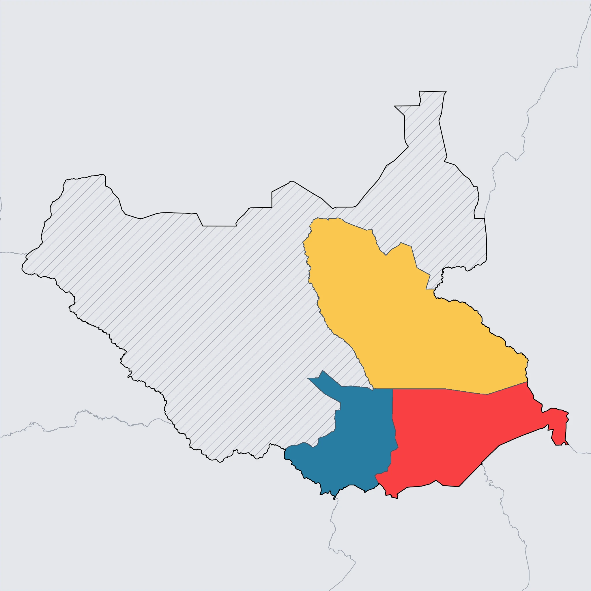
White Nile Corridor (Central Equatoria State)
The river that shapes a nation 🌊
⚠️ SAFETY WARNING: Due to the persistent threat of armed conflict, violent crime, and kidnapping, government agencies (including CA, USA, UK, AU, IE, and NZ) advise travelers to avoid all travel to this region, including Juba. The security situation remains unpredictable and dangerous. Families are strongly urged to consult their own government's official travel advisory before considering a trip, as circumstances and risk assessments vary.
The White Nile Corridor serves as the political and logistical heart of South Sudan. The capital, Juba, sits on the western bank of the Nile, a sprawling city where red earth meets the grey-blue waters of the river. The cityscape is overseen by Jebel Kujur, a distinctive cone-shaped mountain that rises sharply from the flat plains and serves as a major navigation landmark. The river itself is the primary artery of the region, supporting local fishing communities and providing a transport route for barges carrying goods.
South of the capital, the landscape becomes greener and more undulating as it approaches the Ugandan border. This area contains Nimule National Park, situated along the river. The park is known for the Fula Rapids, where the Nile narrows and rushes through rocky channels, creating a powerful display of nature's force. Historically, this park has been a habitat for elephants and hippos, which can sometimes be seen near the water's edge and on the islands scattered within the river.
For families, this region offers the only semblance of urban infrastructure in the country, though it remains very basic by international standards. The climate is tropical, with high humidity and heavy rains during the wet season. Culturally, Juba is a melting pot of the nation's many ethnic groups, creating a busy atmosphere in the markets where fresh produce from the fertile riverbanks is sold. However, movement remains highly restricted due to the security environment, limiting exploration primarily to the immediate river corridor.
Click a region to explore

Activities & Best Times
Hiking, wildlife, outdoor exploration, ecotourism
The corridor offers a unique, authentic opportunity for sunset Nile cruises and serves as the essential gateway to the Sudd wetlands and the Great Migration. The dry winter months (Nov–Jan) provide manageable temperatures and low rainfall for river navigation, while the intense monsoon season (May–Oct) creates difficult travel conditions and high humidity.

Urban tourism, museums, historical sites, architecture
Juba provides a raw, authentic look at the world’s youngest capital with its bustling riverside markets and diverse ethnic heritage, though it lacks global-standard museum infrastructure. Dry months offer the best conditions for exploring local culture on foot, whereas the rainy season brings significant mud and humidity that degrades the urban experience.

Learning experiences, scientific sites, historical education
An important site for sophisticated travelers interested in Nile hydrology and the contemporary history of nation-building in Africa. The dry season allows for reliable access to historical landmarks and ecological research points, while extreme heat in Feb-Mar and heavy rains in mid-year limit educational fieldwork.

Scenic drives, countryside tours, route-based travel
Short excursions to the surrounding savanna and rolling hills offer scenic vistas, though travel requires significant security coordination. The dry peak months (Dec-Feb) ensure the best road conditions and clearest views, whereas the off-season brings rains that often render rural tracks impassable.

Sport tourism, fitness activities, active recreation
The White Nile is famous for Nile perch fishing and traditional dugout canoeing, offering an active connection to the river's heritage. Activities are most comfortable during the cooler peak season; the off-season's extreme temperatures and unpredictable water levels during the rains are less suitable for active recreation.
Attractions (13 total)
Hiking & Cycling Routes
Jebel Kujur Summit Trail
Juba
8.7km (5.4 miles) moderate loop trail with approximately 405m (1,328 feet) elevation gain, taking roughly 3-3.5 hours to complete. This iconic hike offers 360-degree panoramic views of Juba city and the White Nile. No formal equipment rental or bike hire is available; it is highly recommended to hike with a local guide or organized group. Summit elevation is approximately 684m.
Visit website →Fulla Rapids Walking Trail
Nimule
5km easy guided walking route along the banks of the White Nile, taking approximately 1.5 hours with minimal elevation gain (approx. 40m). The trail leads to the powerful Fulla Rapids where the river narrows significantly. All walks must be accompanied by armed park rangers. No equipment or bicycle rental services exist in the vicinity.
Visit website →Castle / Palace / Historic Site
John Garang Memorial
Juba
The final resting place of South Sudan's founding father, featuring a large bronze statue and a solemn mausoleum that serves as a symbol of national identity.
Baker's Tree
Nimule
An ancient tamarind tree used as a camp by explorer Sir Samuel Baker in 1871, offering a tangible link to 19th-century history for visiting families.
Road Trips & Scenic Drives
Juba-Nimule Highway
Juba
192km paved highway (approximately 3-4 hours) connecting the capital to the Ugandan border. This is South Sudan's primary paved scenic route, following the White Nile through lush savanna, passing teak plantations, and ending at the dramatic Fula Rapids of Nimule National Park.
Visit website →National Park / Nature Reserve
Nimule National Park
Nimule
South Sudan's most accessible wildlife park featuring the dramatic Fula Rapids on the White Nile and sightings of elephants, hippos, and crocodiles.
Visit website →Jebel Kujur
Juba
An iconic mountain on the outskirts of Juba offering a popular hiking destination with panoramic views of the city and the White Nile valley.
Botanical Garden / Formal Gardens
Juba Old Botanic Garden
Juba
A historic colonial-era garden featuring a collection of mature indigenous trees and tropical plants along the banks of the White Nile.
Historic Town / Village / Cultural Area
Saint Theresa Cathedral
Juba
As the seat of the Roman Catholic Archdiocese of Juba, this historic red-brick cathedral is a prominent cultural landmark and a peaceful place for reflection.
Nyakuron Cultural Center
Juba
A vibrant public venue that hosts traditional music and dance performances, providing families with a lively introduction to South Sudan's diverse tribal cultures.
Landmark / Monument / Iconic Urban Attraction
St. Theresa Cathedral
Juba
A historic and architecturally striking brick cathedral in the Kator district, serving as a major religious landmark and community center.
Freedom Bridge
Juba
South Sudan's first permanent bridge over the White Nile, this modern engineering marvel serves as a vital link and a symbolic urban landmark.
Fulla Rapids
Nimule
A powerful and iconic natural landmark where the White Nile surges through narrow rock channels, creating a spectacular display of cascading water.