
Ruta de las Flores
Misty mountains, colorful murals, and coffee culture ☕🌸
Click a region to explore
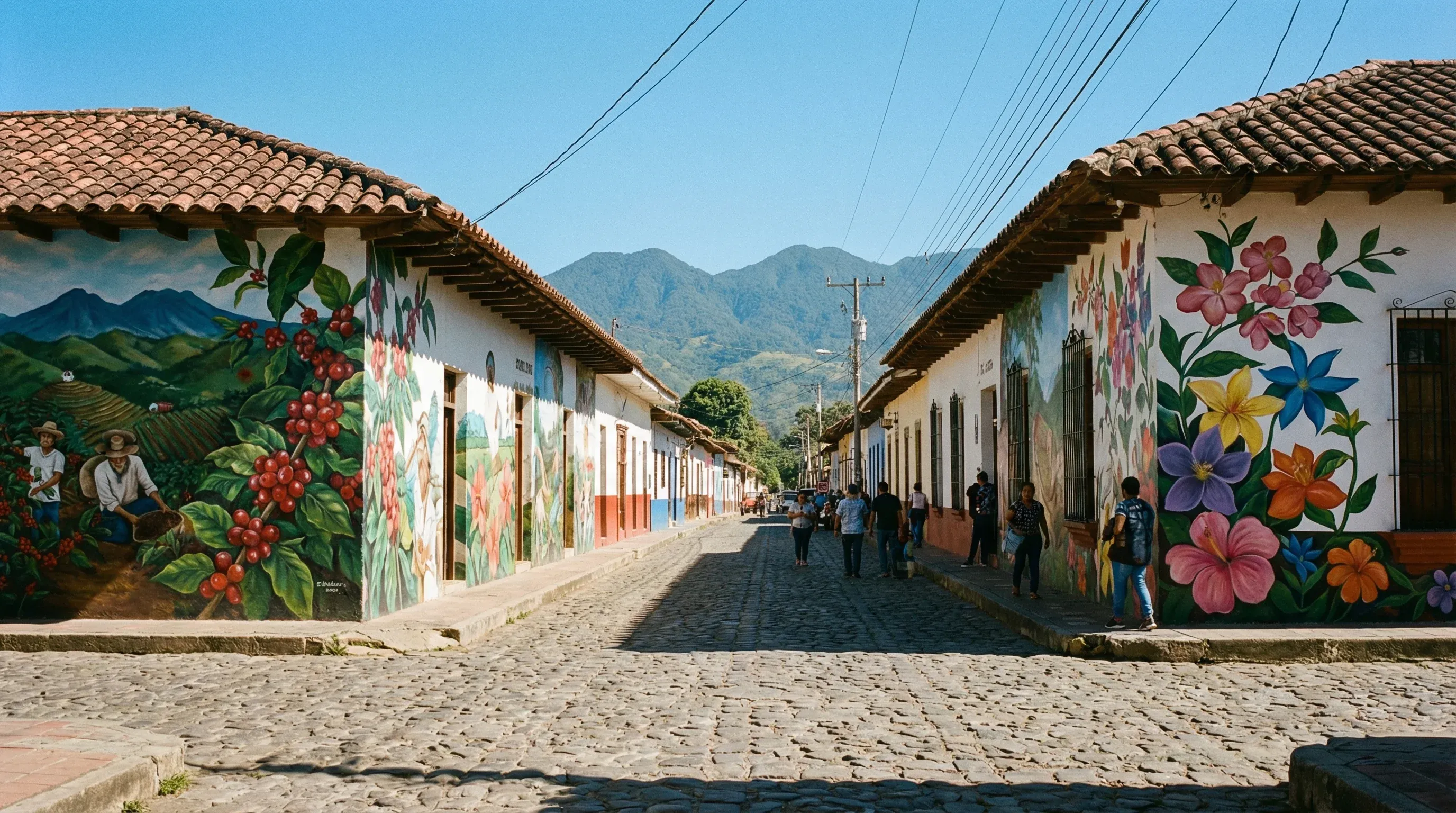
The Ruta de las Flores (Route of the Flowers) is arguably the most family-friendly and enchanting region in El Salvador. Winding through the Apaneca-Ilamatepec mountain range, this scenic road connects five picturesque towns, each with its own unique personality. The air here is crisp and cool—a welcome relief from the coastal heat—making it perfect for exploring with active children. The region is named for the explosions of yellow, pink, and orange flowers that line the road (best seen November to February), but the cultural vibrancy lasts year-round. Families will find a safe, welcoming atmosphere where cobblestone streets lead to artisan markets, and local plazas come alive on weekends with music, ponies, and food stalls.
Beyond the towns, the geography is defined by lush coffee plantations and volcanic peaks. This is the heart of El Salvador’s coffee country, offering an educational opportunity for kids to see exactly where their parents' morning brew comes from—from red cherry to roasted bean. The landscape is dotted with waterfalls and hot springs, offering adventures that range from mild nature walks to exciting canopy zip-lines over the forest canopy. The slow pace of life here encourages families to linger, explore street art, and enjoy the hospitality of the highlands.
Key Attractions
For active families, the headline attraction is the Santa Ana Volcano Hike (Ilamatepec). While technically a challenge, the hike is accessible for older children and active parents. The reward at the summit is breathtaking: a turquoise sulfur lake steaming inside the massive crater, with views stretching all the way to the Pacific Ocean. It is one of the most iconic experiences in Central America. Ensure you book a guide and check safety conditions before ascending.
While exploring the route, a short drive connects you to the neighboring city of Santa Ana, home to the magnificent Santa Ana Cathedral. This Neo-Gothic masterpiece is awe-inspiring for children and adults alike, with its intricate moldings and white facade. Combining the nature of the Ruta with this cultural landmark creates a perfect day of contrasts.
Practical Advice
The best time to visit is during the dry season (November–April) when the flowers are blooming and hiking trails are dry. However, weekends can be crowded with domestic tourists, especially in Juayúa and Ataco. If you seek quiet, visit mid-week; if you want the full festive market experience, aim for Saturday.
Food & Drink
Typical meal times: Breakfast 7:00 am to 9:30 am. Lunch is the main event, especially on weekends, from 12:00 pm to 3:00 pm. Dinner is usually 6:30 pm to 8:30 pm.
Typical meal costs: Very affordable. A hearty meal at a food festival costs $6–10 USD (approx. €5.50–9 EUR / £4.50–8 GBP). Restaurant meals range from $12–20 USD (approx. €11–18.50 EUR / £9.50–16 GBP).
Dietary requirements: Vegetarian options are plentiful, with corn, beans, cheese, and avocado being staples. Vegan travelers may need to clarify "no cream/cheese" on dishes. Nut allergies are generally rare in local cuisine, but always check.
Signature dishes:
- Yuca con Chicharrón – Boiled or fried cassava root served with curtido (pickled cabbage) and crispy pork crackling, served on a banana leaf.
- Gallo en Chicha – A sweet and savory rooster stew cooked with fermented pineapple drink (chicha) and spices.
- Chorizo de Cojutepeque – While from a nearby region, these famous sausages are a staple at the Juayúa food festival.
Why this score?
Adventure here is characterized by 'soft' outdoor activities such as navigating the Laberinto de Albania, coffee plantation tours, and hiking to the Los Chorros de la Calera waterfalls. The terrain is mountainous and lush, offering a refreshing climate, but the paths are generally well-trodden and accessible to families with children. It provides a moderate level of physical engagement without being truly remote or high-risk.
Why this score?
The small colonial towns along the route have basic health outposts (Unidades de Salud) that are better suited for residents than for international tourists. For anything beyond basic first aid, travelers must go to the nearby city of Sonsonate or the more distant Santa Ana. English-speaking medical staff are very rare in this rural highland region.
Why this score?
This scenic route is a staple for domestic tourism and is highly regarded by regional travelers for its coffee culture and colonial architecture. While it is the second most popular circuit in the country, it remains a niche international destination primarily visited by those already exploring Central America. It lacks the large-scale resort infrastructure required for higher global popularity scores.
This region offers exceptional value. Charming boutique hotels and B&Bs often cost between $60–100 USD (approx. €55–92 EUR / £48–78 GBP) per night. Entry to natural parks and waterfalls is often minimal ($3–7 USD / €2.75–6.50 EUR / £2.30–5.50 GBP). The weekend food festivals provide a feast for under $10 USD (approx. €9 EUR / £8 GBP) per person.

Getting Here & Around
Getting Here
- Driving – The most practical way to explore. It is about 1.5 to 2 hours from San Salvador or the coast. The road is paved and in good condition but winding.
- Bus – Local buses (Route 205 to Sonsonate, then 249) connect the towns, but this can be slow and crowded with luggage and children.
- Tours – Many operators run day trips from San Salvador that cover the main highlights comfortably.
Getting Around
- Car – Highly recommended for freedom. You can stop at viewpoints and travel between towns like Juayúa and Apaneca in 15–20 minutes.
- Walking – The individual towns (Ataco, Juayúa) are small and best explored on foot.
- Tuk-tuks – Available in the towns for short hops within the urban limits; fun for kids but negotiate the price first.
No airports in this region. See the country flight map for nearby connections.

Packing List
Temperatures drop significantly in the evenings due to the altitude.
The road connecting the towns is extremely winding and can affect children.
Trails to waterfalls and volcanoes can be muddy and steep.
Many artisans and food stalls at the weekend markets do not accept cards.
Beaches like El Tunco are rocky (stones, not sand) and river waterfalls can be slippery.
Evenings in mountain towns like Apaneca and Ataco can get surprisingly chilly (down to 15°C/60°F).
Fireworks are very common year-round for celebrations, often late at night or early morning.
Street lighting in smaller colonial towns can be dim or sporadic during power fluctuations.
The tropical heat and humidity deplete you quickly; local options aren't always kid-friendly flavors.

Activities & Best Times

Hiking, wildlife, outdoor exploration, ecotourism
Rating remains very_good but justification needs correction - Santa Ana Volcano is NOT in this region. The very_good rating is supported by the Seven Waterfalls (Los Chorros de la Calera), coffee highlands biodiversity, and the concentration of waterfall systems. Notes should reference actual attractions in this region.

Urban tourism, museums, historical sites, architecture
Features a dense collection of authentic colonial towns like Ataco and Juayúa alongside indigenous heritage in Nahuizalco. The dry season (Nov-Apr) is optimal for exploring street art, coffee cooperatives, and outdoor food festivals, which are central to the region's cultural appeal.

Sport tourism, fitness activities, active recreation
Boasts significant adventure infrastructure including high-altitude cycling loops and the popular Cafe Albania activity center. Peak visitation aligns with the dry season to ensure full access to outdoor equipment and mountain hiking routes which become slick during the tropical wet season.

Scenic drives, countryside tours, route-based travel
A well-defined and celebrated scenic route through high-altitude coffee plantations and flower-lined mountain passes. Driving conditions are best from November to February when the local flora is in bloom and visibility across the Apaneca range is at its highest.

Spa retreats, wellness centers, peaceful getaways
Offers unique geothermal experiences like the hot water falls of Malacatiupán, though facilities are more rustic than international luxury standards. These thermal sites are best visited in the drier months when surrounding river levels are controlled and access roads are reliable.

Amusement parks, family entertainment venues
Contains local aquatic centers like Atecozol that serve as regional entertainment hubs, though they lack the scale of global theme parks. These outdoor venues are primarily visited during the sunny peak season when families seek water-based recreation.


Public Holidays & Calendar Next 12 months
Public holidays, festivals, cultural celebrations, and seasonal natural phenomena coming up in Ruta de las Flores over the next 12 months.
Loading holidays and events...

Travel Advisory
Most major agencies recommend exercising a high degree of caution or increased vigilance. While the security situation regarding gang violence has significantly improved since 2022, the ongoing 'State of Exception' allows for expanded police powers and the suspension of certain constitutional rights.
Safety Topics
Traveller Advice (4 groups)

Female travellers should consult specific safety guidance regarding solo travel and remain vigilant in public spaces.

Ensure you carry valid identification at all times as security checkpoints and searches are common. Avoid displaying wealth or travelling alone at night, especially in rural or less populated areas.

When visiting volcanoes or remote hiking trails, it is highly recommended to use certified local guides and conduct activities during daylight hours to ensure safety.

Specific resources are available for sexual and gender minority travellers to navigate local social norms and legal differences.
Agency Summaries
While the security environment has gotten better and crime rates have dropped, a state of emergency persists, and travellers are advised to stay alert to their surroundings.
Travellers are encouraged to be careful and avoid areas where security operations are active, as the country continues to operate under a national state of emergency.
Due to concerns regarding violent crime, travellers should exercise a higher level of awareness than they normally would, particularly in urban centers.
Safety conditions have improved notably as gang-related activity and homicides have decreased; however, a state of exception remains in effect which limits certain rights.
High levels of caution are recommended due to the persistent threat of violent crime, even though security measures have led to some reductions in gang activity.
Visitors should maintain heightened vigilance because of the ongoing risk of crime and the potential for arbitrary enforcement of local laws under current emergency measures.
Information is provided for general guidance only and does not constitute travel, safety, medical, or legal advice. Conditions may change. Users are responsible for independently verifying information before travel.