
Pamir Highway & GBAO
A high-altitude adventure on the Roof of the World 🚙
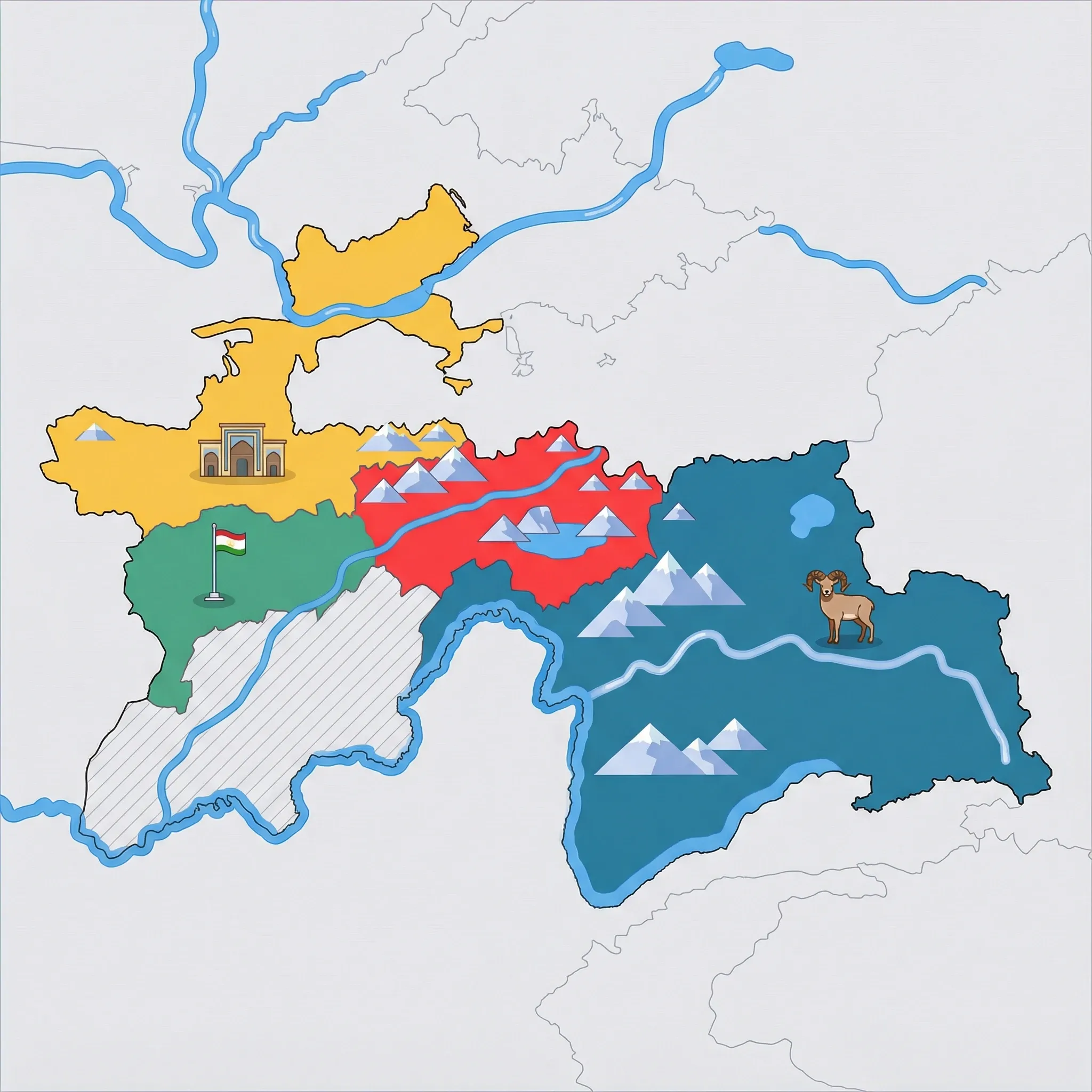
Click a region to explore
⚠️ SAFETY WARNING: Due to political volatility, occasional civil unrest, and extreme remoteness, government agencies (including CA, USA, UK, AU, IE, NZ) advise travelers to reconsider travel to the Gorno-Badakhshan Autonomous Region (GBAO), particularly areas near the Afghan border. The security situation can change rapidly, and medical facilities are basic to non-existent. Families are strongly urged to consult their own government's official travel advisory before considering a trip, as circumstances and risk assessments vary.
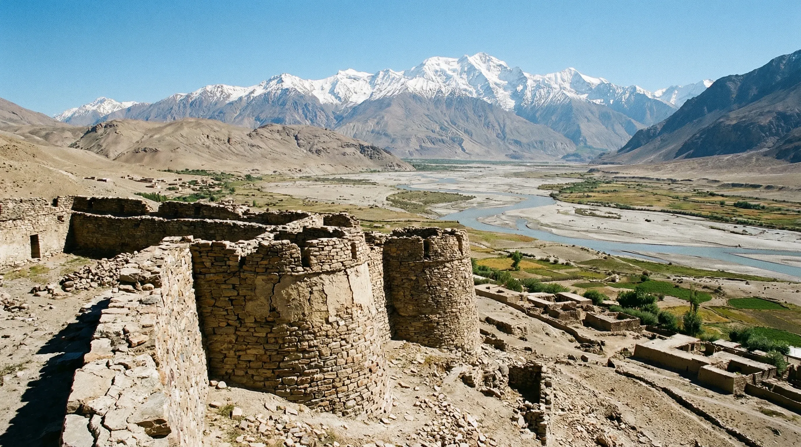
For families who choose to undertake the journey, the Pamir Highway (M41) offers one of the most visually arresting experiences on the planet. This is not a holiday for relaxation; it is an expedition. The region is a high-altitude plateau often exceeding 4,000 meters, resembling the surface of Mars with its stark, treeless mountains and vast salt lakes. The isolation is profound. You will drive for hours seeing nothing but golden marmots, herds of shaggy yaks, and the occasional yurt. For teenagers or resilient older children fascinated by geography and nature, this is a living classroom. The culture here is Pamiri, distinct from the rest of Tajikistan, with its own languages, Ismaili religion, and unique house architecture (Pamiri houses).
Travel here requires patience and preparation. Electricity can be sporadic, hot showers are a luxury, and distances are vast. However, the rewards are unique: soaking in natural hot springs under the Milky Way, staying in homestays where families sleep on raised platforms around a central skylight, and seeing the Afghan villages just across the Panj River. It is a place that teaches resilience and offers a perspective on how people survive in the harshest environments on Earth.
Key Attractions
The journey itself is the attraction, specifically driving the M41 Pamir Highway. It winds through high passes like Ak-Baital (4,655m). A major highlight is Karakul Lake, a massive meteor crater lake that sits higher than Lake Titicaca. The water changes color from turquoise to deep blue, and the village on its shore feels like the edge of the world. The route cuts through the Tajik National Park, a UNESCO World Heritage site known for its glaciers and biodiversity, including the elusive snow leopard (though you are unlikely to see one, knowing they are there is thrilling for kids).
Practical Advice
Best Time to Visit: July and August are the only months where snow is cleared from all passes and temperatures are bearable (though still cold at night). June and September are risky for weather.
Logistics: You must have a GBAO permit in addition to your Tajik visa. Do not attempt this self-drive unless you are an expert off-road mechanic. Hiring a driver with a Land Cruiser is the standard and safest way. Altitude sickness is a real risk for children; ascend slowly and carry Diamox (consult your doctor).
Food & Drink
Typical meal times: Meal times are dictated by when you arrive at a settlement. Breakfast is usually 7:00 am to 8:30 am.
Typical meal costs: Food is scarce and usually included in the price of homestays. If paying separately, a simple meal is 40–60 TJS (approx. $3.50–5.50 USD / €3.30–5 EUR). Imported goods in Murghab are expensive.
Dietary requirements: This is the hardest region for dietary restrictions. Fresh vegetables are rare in the high Murghab plateau. The diet consists of bread, yak meat, dairy, and rice. Vegetarians should bring supplements and protein bars.
Signature dishes:
- Shirchai – A savory tea made with milk, salt, butter (sometimes yak butter), and old bread. It is an acquired taste but the staple breakfast of the Pamirs.
- Yak Meat – Leaner and darker than beef, found in soups and plov throughout the high plateau.
- Qurut – Hard, dried balls of salty yogurt. They are rock-hard and sucked on like savory candy—kids often find the texture challenging but the taste interesting.
Why this score?
Traversing the 'Roof of the World' involves navigating high-altitude plateaus, unpaved roads, and extreme weather conditions with minimal support. The physical demands of the altitude and the sheer isolation of the Wakhan Valley make it one of the most adventurous road-trip regions globally. Accommodations are restricted to basic guesthouses with limited electricity and no running water in many sections.
Why this score?
Outside of the small hospital in Khorog, medical infrastructure along the M41 is extremely primitive and limited to basic first aid. The lack of pharmacies, specialized care, and the high risk of altitude sickness make this a high-risk area for those without comprehensive travel insurance and evacuation plans. Any major medical event here would necessitate a difficult and lengthy transport to Dushanbe or abroad.
Why this score?
The Pamir Highway is a legendary 'overlanding' route that attracts a small but dedicated group of adventure travelers and cyclists annually. Despite its cult status in the travel community, the extreme remoteness, altitude, and permit requirements keep total visitor numbers very low relative to global standards. It remains a bucket-list item for niche travelers rather than a mainstream destination.
While accommodation is basic, the cost is high due to transport. Hiring a private car and driver costs $100–150 USD (approx. 1,100–1,650 TJS / €92–140 EUR) per day. Fuel is expensive in remote areas. Homestays are reasonable at 150–250 TJS (approx. $14–23 USD / €12–21 EUR) per person.

Getting Here & Around
Getting Here
- Driving – The only way in. The drive from Dushanbe to Khorog (the gateway) takes 14-16 hours minimum, often split over two days. The road is rough, partly unpaved, and winds along the Afghan border.
- Flight – Small planes occasionally fly Dushanbe-Khorog, but they are notoriously unreliable, flying only on clear days. It is considered one of the most dangerous and scenic commercial flights in the world.
Getting Around
- 4WD Rental – Essential for the M41 Pamir Highway. Sedans cannot handle the terrain.
- Shared Taxi – Possible between major towns like Khorog and Murghab, but uncomfortable for families with luggage.
- Walking – Once at a destination (like a lake or village), walking is the only way to get around.
No airports in this region. See the country flight map for nearby connections.

Packing List
Bedding in remote homestays is clean but rarely changed daily; a liner adds hygiene/warmth.
The high altitude air is incredibly dry; skin cracks within days without it.
Electricity is unreliable or absent in many villages; outdoor toilets are pitch black at night.
Rarely provided in drop toilets along the highway. Carry your own supply.
Tap water is generally unsafe. A Steripen or filter bottle saves money and reduces plastic waste in remote areas where recycling doesn't exist.
Power outages are frequent, even in cities. Street lighting is minimal, and navigating homestay toilets at night requires light.
ATMs are rare outside Dushanbe. You must bring cash in pristine condition (no tears/marks) to exchange; old notes are often refused.
Public bathrooms are often simple pit latrines with no running water or paper. Essential for hygiene on the road with kids.
"Tajik Tummy" is common. Electrolytes are vital for recovery, especially given the altitude and long travel days.
Roads in the Pamirs and Fanns are incredibly winding and rough. Essential for children prone to car sickness.

Activities & Best Times
Hiking, wildlife, outdoor exploration, ecotourism
Home to the UNESCO-listed Tajik National Park, this region offers some of the world's most dramatic high-altitude wilderness and trekking experiences. Visitation is strictly limited to the short summer window when the high-altitude passes are clear of snow and the Pamir Trail is navigable for families.

Urban tourism, museums, historical sites, architecture
Features an exceptional concentration of Silk Road heritage, including the Yamchun and Khaakha fortresses, alongside the distinct Ismaili culture of the Wakhan Valley. The cultural experience is most accessible from late spring to early autumn when local mountain communities are active and Khorog is at its most vibrant.
Scenic drives, countryside tours, route-based travel
The M41 Pamir Highway is globally renowned as one of the most scenic and challenging driving routes, traversing high plateaus and the dramatic Ak-Baital Pass. Severe winter weather and road conditions make the route dangerous or impassable outside of the peak summer and shoulder months.

Sport tourism, fitness activities, active recreation
The region is an international magnet for high-altitude cycling and remote trekking, supported by major routes like the Pamir Trail and the Jizeu Valley. Due to extreme elevations and thin air, peak physical activity is only advisable during the warmest months of July and August.

Spa retreats, wellness centers, peaceful getaways
Authentic natural hot springs such as Jelondy and Issyk Bulak provide unique restorative stops for travelers, though facilities are rugged and lack international luxury spa standards. These sites are best visited during the primary tourism season when accessibility across the GBAO plateau is reliable.


Public Holidays & Calendar Next 12 months
Public holidays, festivals, cultural celebrations, and seasonal natural phenomena coming up in Pamir Highway & GBAO over the next 12 months.
Loading holidays and events...

Travel Advisory
All major agencies maintain an elevated risk level for Tajikistan. The primary nationwide concerns are terrorism and crime, while severe regional warnings are in place for the Afghan and Kyrgyz borders and the Gorno-Badakhshan region due to conflict and landmines.
Safety Topics
Traveller Advice (4 groups)

While not illegal, same-sex relationships are not widely accepted in this socially conservative society, and there are no specific legal protections against discrimination.

Be aware that mountain rescue services are extremely limited. Avoid trekking in remote border areas due to the high risk of unexploded landmines, which are often poorly marked.

Exercise high vigilance, particularly at night, due to reports of sexual assault and drink-spiking targeting foreigners. Modest dress is recommended to respect local cultural and religious norms.

Ensure you carry a photocopy of your identification at all times as local police frequently conduct identity checks. Stays exceeding 10 days require mandatory registration with local authorities (OVIR).
Agency Summaries
Irish citizens are advised to be highly cautious. Tensions along disputed border areas often lead to clashes involving firearms, and travel to the Gorno-Badakhshan Autonomous Region is discouraged.
Increased safety precautions are recommended due to the threat of terrorism and common street crimes such as muggings and drink-spiking. Regional instability justifies higher risk ratings in border zones.
Visitors should maintain elevated vigilance due to the persistent threat of terrorism and organized crime. Travel near the Afghan border is strongly discouraged due to extreme security risks, and visits to the Gorno-Badakhshan region should be limited to essential purposes only.
While general travel is permitted, significant regional risks exist. Specific areas, including those near the Afghan and Kyrgyz borders, are subject to heightened security warnings due to the potential for localized violence and terrorism.
A high level of caution is advised countrywide because of the risk of civil unrest and terrorist activity. Security conditions near the border with Afghanistan are particularly volatile and should be avoided.
Heightened awareness is necessary throughout the country due to terrorism risks and the presence of unexploded landmines. Conflict potential is notably higher in Gorno-Badakhshan and along the borders with Afghanistan and Kyrgyzstan.
Information is provided for general guidance only and does not constitute travel, safety, medical, or legal advice. Conditions may change. Users are responsible for independently verifying information before travel.